The use of poles in mountaineering

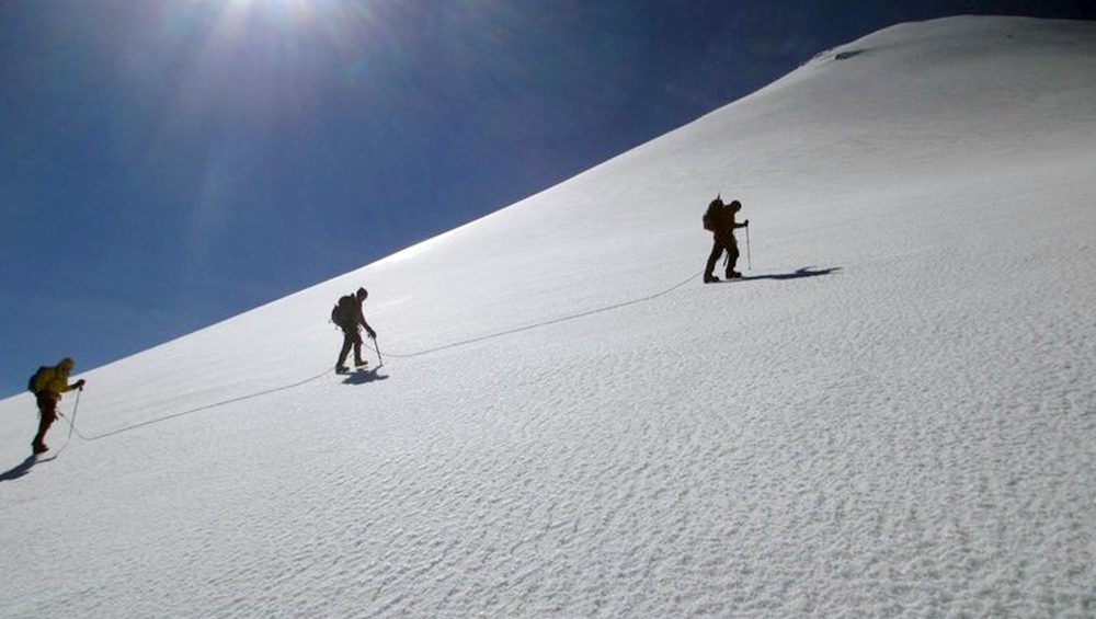
Poles, our great ally in the mountains

The use of poles offers many advantages. What are the benefits of using poles?

Reduction of the workload

Several studies prove that the reduction of the load on the legs during ascents is around 14%, while during descents it is around 20%. Therefore, the use of poles allows us to prevent muscle injuries in the joints, specifically in the knees.

Balance

Our balance improves because we have four points of support.The probability of falling decreases, especially on descents, and therefore increases our safety.


Performance

All this translates into better performance: we save forces that will allow us to complete our ascents or expeditions.


Upper Body

Naturally, the use of poles means a slight increase in effort in the upper body, if you use a good "poling" technique. The poles are not designed to be leaned on with our full weight.


Technique

If we observe experienced climbers, we will see how the pole "accompanies" their movement, resulting in a harmonious step, in which the poles are an extension of their arms.

Conclusion

A climber who uses poles regularly will be in much better condition at the end of his career than one who has not used them.

Which volcano is harder, Iztaccihuatl or Pico de Orizaba?

Let's start with the basic measurements. In both cases we will base ourselves on the normal route; the Portillos route on Iztaccihuatl and the north face route on Pico de Orizaba.

Iztaccíhuatl measures 5,220 meters, and is usually climbed from approximately 3,970 meters from La Joyita, where the main parking lot is located. The vertical drop is, therefore, about 1,250 vertical meters. The estimated distance is fourteen kilometers, seven uphill and seven downhill.


The Pico de Orizaba measures 5,636 meters; the ascent usually starts from the Refugio de Piedra Grande, at 4,240 meters. La ganancia vertical es de unos 1,396metros. The vertical gain is about 1,396 meters. The total distance covered is also about fourteen kilometers.


The Pico de Orizaba Orizaba is objectively harder,as it requires overcoming a greater vertical gain at a higher altitude. In addition, the last five hundred meters of the Jamapa Glacier are inevitably uphill. As veteran Joaquín Canchola of Tlachichuca rightly says, "'El Pico is a madriza!" (climbing Pico is like taking a beating!).

However, to assess the overall difficulty or hardness, another fundamental factor arises: which descent is harder? After all, every mountain must be descended, once the summit has been reached.


On the other, on Iztaccihuatl, one must traverse the Ayoloco Glacier on a combination of ascending, descending, and even horizontal terrain (the well-known "Belly" of the glacier).

The answer is debatable, but many of us maintain that Pico de Orizaba is easier to descend than Iztaccihuatl. Why? Because the descent is a steady downhill, over relatively easy terrain, while Iztaccihuatl requires several partial ascents, such as Monte de Venus or La Rodilla, and semi-technical terrain around the Cruz de Guadalajara (4,900 meters). In general, the descent of Pico was faster and less strenuous than that of Mujer Blanca.


In addition, there are other factors to take into account. For example, the beginning of the Portillos route route is less steep than its equivalent on the Pico, which allows us to dose the effort. The state of the terrain, depending on the weather, is another factor that can make the ascent and descent of El Laberinto tremendously easy or highly complicated.


And you, fellow mountaineer, what do you think? Which is harder for you, Iztaccihuatl or Pico de Orizaba?

North or south face of Pico de Orizaba?

Many times our clients ask us which side of Pico de Orizaba is more convenient for them, the north or the south.

These are the advantages and disadvantages of each option:

Advantages of the south face of Citlaltépetl:

  1. 400 meters less elevation gain than the north face
  2. much faster descent (three hours compared to five)
  3. less hours of duration (ten versus thirteen on average)
  4. less loaded backpack (you don't need neither harness nor ice axe, and you carry less water)
  5. quieter base camp
  6. you can climb the Sierra Negra (4,580m) to acclimatize the day before the summit

On the south face we camp in the Valle del Encuentro (4,000m), where the annual Mexican Mountaineers' Gathering is held. The night of the summit we ascend in a 4x4 vehicle to the parking lot at 4,600 meters, and from that point we start.


Advantages of the north face of Citlaltépetl:

  1. more beautiful alpine scenery
  2. possibility of ascending a glacier
  3. experience of walking in a roped team

On the south face we camped near the Piedra Grande refuge (4,200 meters), and from that point we left for the summit night.

To sum up:

  • If your goal is to secure the summit, or you have not been able to train and acclimatize sufficiently, and if walking on snow is not important to you, the south face is your option.
  • If you want an extreme physical challenge, to enjoy alpine landscapes and to have the experience of walking on a glacier with a rope, the north face is for you.

Secrets for Elbrus

Success factor in climbing a five-thousander


In August 2016 we led an expedition to Mount Elbrus, 5,642m, situated in the Caucasus, and considered Europe’s tallest peak.


This mountain is only six meters taller than Pico de Orizaba, and is of similar degree of difficulty. Therefore, the tips offered in this blog apply to the Mexican volcanoes above 5,000 meters.


These were the factors that made our AdvenCulture-led climb successful:


-We devoted five full days to achieving the best acclimatization possible. We started with a simple trek to 3,000 meters, and gradually increased our altitude to 4,300, 4,700, etc.


-We took two full days of rest before the summit push. We make a point of going to bed early the previous night (we were lying down at 18h!).


-We checked the weather forecast closely, and chose a day with almost no wind and mild temperatures for our summit push (the lowest was -10 Centigrade).


-We drank and ate at every stop on the glacier. We made short pauses, so that we would not get too cold.


-During the descent, we took advantage of favorable terrain to slide down from 5,100 to 4,700 meters, thus saving considerable time and energy.


The result was great: all three German customers made it to the summit of Europe, and returned safely from our South Face climb.


Wir haben es geschaft!!!

The normal route of the Mont Blanc

The ideal ascent to Mont Blanc entails using the huts of Tête Rousse and Le Goûter. This plan allows us to split the effort in three days, to have a good degree of acclimatization, and to enjoy the wonderful landscapes of the Alps. Furthermore, you avoid having to carry heavy loads, because the huts offer anything you may need for food or hidration (they sell wine and beer, too!!!)


To get to Tête Rousse you have to take the Tramway du Mont Blanc, the oldest cogwheel train in the Alps. You can board it at Saint Gervais, or take it at the Bellevue station, in which case you will take a cable car from Les Houches.


The train stops at the Eagle’s Nest, the terminus, at 2,372 meters. You then walk on easy terrain to Tête Rousse, which stands at 3,200 meters. It will take you between two and three hours. It is an excellent hut, with a nice restaurant y comfortable beds.


The ideal ascent to Mont Blanc entails using the huts of Tête Rousse and Le Goûter. This plan allows us to split the effort in three days, to have a good degree of acclimatization, and to enjoy the wonderful landscapes of the Alps. Furthermore, you avoid having to carry heavy loads, because the huts offer anything you may need for food or hidration (they sell wine and beer, too!!!)


To get to Tête Rousse you have to take the Tramway du Mont Blanc, the oldest cogwheel train in the Alps. You can board it at Saint Gervais, or take it at the Bellevue station, in which case you will take a cable car from Les Houches. The train stops at the Eagle’s Nest, the terminus, at 2,372 meters. You then walk on easy terrain to Tête Rousse, which stands at 3,200 meters. It will take you between two and three hours. It is an excellent hut, with a nice restaurant y comfortable beds.


The second day begins with the traverse of the infamous Grand Coloir, also known as the “Bowling Alley” (guess what, we are the bowls!!!). This couloir is exposed to rock fall, and several accidents happen here every year. The earlier you cross it, the safer you will be. We then climb up a beautiful wall to the Le Goûter hut, at about 4,000 meters. The technical sections are equipped with a thick cable, acting as a fixed rope. You should have your harness on, as well as a life line. We recommend wearing thin gloves, as the cable is torn in some places, and could easily cut you. Some times the use of crampons will be advisable, so carry them at hand.


After another night’s rest, we shall start the summit push at five am. We must still climb 800 vertical meters. The terrain is relatively simple, to the extent that some climbers do not wear helmets (we always wear it, safety is first, and also you will look more like a pro in the photos). The main risk is that you could fall in a crevasse or down the ridge, so we will rope up at all times.


The wisest is to reach the summit around nine, so we have ample time to descend to Chamonix that same day. The downclimb follows exactly the same path we have used to the summit. The last train leaves the Eagle’s Nest at six pm.


 You can also contact us at:


pachi@advenculture.com

Large international expeditions

 Recently we had the opportunity to guide an expedition to the Citlaltépetl for a large group of French alpinists.


Large international expeditions require careful preparation. 


These are some of the aspects we meticulously care about at AdvenCulture:


-We make sure our customers have the necessary level of fitness and adequate equipment for the climb.


-We inform our clients well in advance of the itinerary, the proposed menu and the weather forecast.


-We lead a acclimatisation trek, with the double goal of improving their response to altitude, and of assessing their physical condition, in order to group them in the best possible teams for summit day.


-We keep regular contact by radio between the teams and the base camp, so that we can quickly react to any situation.


-We employ guides with the necessary experience and linguistic skills; for instance, in this past expedition, all three guides were trilingual.


The result was excellent: six of our seven customers made the summit, after an exciting climb up the north face of the Pico de Orizaba.


Nous sommes très fiers de nos clients français dans le Pico de Orizaba!


Nous sommes spécialisés en expeditions de haute montagne au Méxique avec des étrangers. Nos guides parlent six langues européennes.